If the county has a Certificate of Survey on file for your property, it may help with locating the corner monuments. However, not all property corners are marked with corner monuments. If your property has never been surveyed, you may need to contact a licensed land surveyor to do a boundary survey. Beltrami County does not do private boundary surveys for individual properties. We only preserve and maintain PLSS corners which are commonly referred to as section corners.
Land Survey Records
Frequently asked questions:
How do I find my property lines and/or corners?
What do survey markers look like?
On an ordinary city lot, the most common type of marker is an iron pipe or rod driven in the ground. A newer marker will include a plastic cap or a metal disk bearing the license number of the surveyor under whose supervision it was set. These are usually four- or five-digit numbers, with the letters "LS", "PLS", or "RLS" above or before the number. Unfortunately, the cap or disk sometimes is knocked off or damaged by grading or excavation work.
These markers are set at lot corners and at points where property lines change direction. They are usually driven level with the ground when installed. Over the years, a few inches of dirt and sod can cover them. If the lot was graded after the markers were installed, they can be buried more deeply or may be missing entirely.
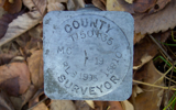
Section monuments may be stone, concrete, cast iron, cast aluminum, or large pieces of pipe. Section monuments set by a County Surveyor are usually marked as such.
Many other types of survey markers exist.
(Information provided by the Minnesota Society of Professional Surveyors)


I found a survey marker with a number on it. How do I locate the surveyor?
All licensed surveyors are listed by name and number with the State board that regulates the design professions. This board is formally called the State Board of Architecture, Engineering, Land Surveying, Landscape Architecture, Geoscience, and Interior Design. We will refer to it hereafter as the State Board.
The State Board's Web site will give the name of a surveyor from his or her license number. You can also get that information by calling the State Board (651-296-2388). The State Board can also provide further information by phone, which sometimes includes an office address and phone number.
The Minnesota Society of Professional Surveyors (MSPS) can also provide the name of a surveyor from his or her license number. MSPS also has office addresses and phone numbers for surveyors who are members of MSPS. About 75 percent of the licensed surveyors in Minnesota are members of this organization.
When a surveyor dies or retires, his or her records are usually taken over by another firm. These records can be very important in retracing boundaries that were run by that surveyor. In many cases, MSPS has information on where such records are located.
(Information provided by the Minnesota Society of Professional Surveyors)
How much will it cost to have my property surveyed?
The cost for surveying a given piece of property generally has to be determined individually for that property. The two main factors are:
- Where is the property located, and how large is it? Property lines are more expensive to survey in some areas due to problems with old surveys, incomplete records, or missing survey markers. Larger pieces of land require a survey crew to spend more time on site. Steep slopes, woods, brush, and wetlands also slow down the work.
- How much information is needed, and for what purpose? A survey might include only the property lines. Or an existing house or other buildings might need to be measured and shown on a drawing. Fences, walls, or utility lines may need to be located. Trees sometimes need to be located with respect to property lines. If the property is to be regraded, or plans prepared for a new home or building, the architect or designer may need to know existing ground elevations at various spots, and may ask that a contour map be prepared. If there is a legal question connected with the property lines, an attorney may ask the surveyor to do additional work to help in resolving the matter.
(Information provided by the Minnesota Society of Professional Surveyors)
Is the city or county responsible for providing survey markers at the corners of my property?
No. When property is platted, state law requires that survey markers, or monuments, be placed at all lot corners. The law only requires this to be done once. The cost is normally paid by the land developer. These markers are sometimes knocked out when the land is regraded or utilities are installed. Having them replaced is the individual property owner's responsibility.
If you are buying a lot in a new subdivision, the cost for having any missing survey markers replaced is moderate since the land has recently been surveyed. It is possible to ask the seller to have any missing monuments replaced. The seller may or may not be willing to do so.
In rural areas, most land boundaries are controlled by section monuments. Many counties, though not all, maintain these monuments at public expense. This is a sensible policy, since each monument affects the boundaries of up to 1280 acres of land. But section monuments are at least half a mile apart, and do not mark all the corners of most pieces of rural land. Survey markers other than section monuments are placed and maintained at the expense of private landowners.
(Information provided by the Minnesota Society of Professional Surveyors)
First, try to talk with the surveyor who did the work. Most surveyors are willing to spend some time explaining the property line to a neighbor, although their schedules are often very busy. In establishing a property line, a surveyor is always aware that it has two sides. He or she will make every effort to locate the line in such a way as to respect the rights of neighbors.
If you are unable to contact the surveyor who laid out the line in question, or if you don't understand the explanation you are given, you may need to hire a surveyor of your own to check the line.
Whenever there is a question or dispute about a property line, be sure to mention that to any surveyor you are thinking of hiring. These situations often involve extra work, and it is best to inform the surveyor in the beginning to prevent a misunderstanding about the cost later on. Some surveyors prefer not to work on disputed boundaries at all, partly due to the difficulty of predicting the cost of such work.
(Information provided by the Minnesota Society of Professional Surveyors)
Unfortunately, land surveying is not an exact science. Surveyors work from plats, deeds, and other documents in the courthouse records, and also from monuments and other physical objects which serve as evidence of where the boundary is located. In some areas, the items found in the field may not agree with the records or with each other, or the records themselves may be incomplete, ambiguous, or contradictory. When two surveyors attempt to determine the correct location of the property line in such cases, they may reach different conclusions although both are acting in good faith.
Boundary problems are fairly frequent in the case of lakeshore property, probably because much of it was originally divided and sold 100 years ago or more. At that time modern laws and regulations were not in place to prevent inadequate surveys and ambiguous legal descriptions.
If you and your neighbor can agree on a compromise location for the property line in question, the problem can be resolved with relatively little trouble and expense. The compromise line should be surveyed and a legal description prepared. An attorney can then draw up a suitable agreement or other document to show that you have agreed on the line. When signed by you and your neighbor, this document can be recorded at the courthouse to prevent future problems.
If you and your neighbor cannot agree, the boundary line can be established by means of a lawsuit. In many cases, however, the cost and time required for a lawsuit may be more than the value of the land involved.
(Information provided by the Minnesota Society of Professional Surveyors)
My property has just been surveyed. The neighbors' fence in partly on my property. What should I do?
When an improvement owned by one person is located on land owned by another person, the situation is known as an encroachment. The laws and court decisions on this subject are complex. To understand your legal rights in such a situation, it is best to consult an attorney, preferably one with experience in real-estate matters.
If you are otherwise on good terms with your neighbor, and if the fence is not in your way, it is probably unwise to start a quarrel over the matter. In most cases, the actual value of the land involved is very small. You can ask your attorney about the possibility of creating an easement or license, which can protect your title to the land involved while allowing the fence to remain in place, either temporarily or permanently. With your attorney's advice, you will also need to decide whether it is necessary and appropriate to do this.
(Information provided by the Minnesota Society of Professional Surveyors)


